What kind of a winter is this? There’s no snow and it’s very mild. Unfortunately there’s no proper ice for ice skating either.

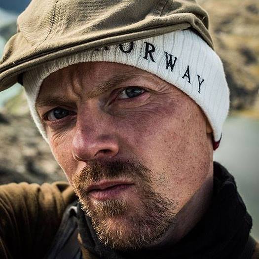
New Years Eve 2019-2020. Oslo.
New Years Eve 2019-2020. Oslo.
This summer a tattoo artist friend of mine from New Zealand came for a visit. She spent a week here and since Oslo is a small city it only takes a few days to see everything this city has to offer, so we decided to go hiking in Jotunheimen for couple of days. On the way there we made a stop at Hedalen Stave Church.

Hedalen Stave Church

Sognsvann, Oslo.

Oslo Opera, Bjørvika.

Power station somewhere between Ålesund & Trollstigen.

Heddal Stave Church

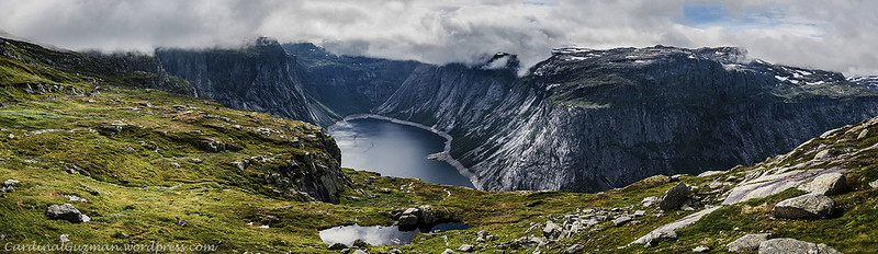
View from Romsdalseggen

Romsdalseggen, Norway.
I went hiking. Just woke up one morning and thought: “I want to go to the mountains”. So that’s what I did: got up, booked a train ticket, packed and went hiking for a couple of days. Now it’s soon off to a tattoo convention to do some photographing and meet up with friends and sexy women.
I’ll post more photos from Romsdalseggen in my next Changing Seasons post.
Enjoy the summer! (winter if you’re down south)


Sunset seen from Tjuvholmen, Oslo.
This HDR panorama is my entry to: https://dailypost.wordpress.com/photo-challenges/names/
Edit: It’s 18 photos processed as HDR, then I created a panorama out of the 6 HDR photos.

I participate in WordPress’ Weekly Photo Challenge 2017
Preikestolen

We started in Oslo, rented a car and drove to the West coast of Norway.
The first day of hiking, we visited Preikestolen (English: Preacher’s Pulpit or Pulpit Rock), one of the most visited natural tourist attractions in Norway (The two most visited is Oslo Opera House and Vigelandsparken in Oslo). “Preikestolen is a steep cliff which rises 604 metres (1,982 ft) above the Lysefjorden. Atop the cliff, there is an almost flat top of approximately 25 by 25 metres (82 ft × 82 ft)” – Wikipedia.
The hike to Preikestolen is an easy one. It has some small parts of uneven terrain and the beginning of the hike is moderately steep, but there are stairs built in the mountain, so anyone can do this hike. Even fat, untrained people can do it.
Kjeragbolten

The second day we walked to Kjeragbolten. “Kjeragbolten is a boulder located on the mountain Kjerag in Forsand municipality in Rogaland county, Norway. The rock itself is a 5-cubic-metre (180 cu ft) glacial deposit wedged in the mountain’s crevasse. It is a popular tourist destination and is accessible without any climbing equipment. However, it is suspended above a 984-metre (3,228 ft) deep abyss.” – Wikipedia
The hike to Kjeragbolten is much more interesting than the ones to Preikestolen and Trolltunga. It has some technical parts and, according to visitnorway.com, it’s a demanding trail: “The hike starts at Øygardstøl south of the Lysefjord by the Lysevegen road above Lysebotn. This demanding trail traverses several ridges, and climbs 570 metres. To avoid wear and tear and accidents, please use the marked trail.” – visitnorway.com
Trolltunga

On the third day we hiked to Trolltunga (the Troll’s tongue). It’s an easy hike, without any technical parts, but it’s a long hike.
Here’s what they have to say about it on visitnorway.com:
“Trolltunga is one of the most spectacular scenic cliffs in Norway. Trolltunga is situated about 1100 meters above sea level, hovering 700 metres above lake Ringedalsvatnet. The view is breathtaking. The hike starts in Skjeggedal and goes through the high mountains, takes 10-12 hours (23 km in total to Trolltunga and return) and the ascent is about 900 meters. It is a long and hard hike. The hike is usually possible to do from mid-June, depending on when the snow melts in the mountains. Normally one can hike to Trolltunga until mid-September. Consider carefully whether you are in good enough shape and have the right equipment before setting out. There is no mobile phone coverage along the route.”
My Italian friend and I did the hike in 6 hours, but the others that we were traveling with, completed it in around 9-10 hours.
If you’re going on any of these hikes: Bring food, water (you can refill the water bottle on the way) proper hiking boots and warm clothes. The weather can change quickly, so it’s a good idea to bring warm clothes in a backpack and to be prepared for possible rain.
Also: leave your walking sticks at home – it’s just stupid and you should rely on your own balance. There’s absolutely no reason to use walking sticks!
(This post is my entry for WordPress’ Weekly Photo Challenge – check out WordPress for more).


Visit my Flickr gallery:
https://flic.kr/s/aHskBnsky8

Here’s another post about Svartisen:
https://cardinalguzman.wordpress.com/2016/07/28/svartisen-glacier-with-a-cherry-on-top/
Here’s a small gallery from my hikes to Preikestolen, Kjeragbolten, Trolltunga and Besseggen.


More edgy photos here: https://dailypost.wordpress.com/photo-challenges/edge/

Lysebotn
Lysebotn is a village in Forsand municipality in Rogaland county, Norway. The village is located at the eastern end of the Lysefjorden in a very isolated valley that is only accessible by one road or by boat. The name itself means the “bottom [end] of the Lysefjorden”. It’s a destination for over 100,000 tourists annually, and it is an access point for the Kjerag mountain, a popular Base Jumping spot. There are cruises and an express boat to Lysebotn from Skagenkaien in the city of Stavanger, Lauvvik in Sandnes and the village of Forsand. All of which pass beneath the famous Preikestolen cliff on the way to Lysebotn. Lyse Chapel, built in 1961, is found at Lysebotn. Lysebotn at one time had its own school, but that is now closed. – Wikipedia

A small lake on the way to Preikestolen.
From Wikipedia: Jötunheimr (or Jǫtunheimr; often anglicized as Jotunheim) is the homeland of the Jötnar, the giants in Norse mythology.
The Legend
From Jötunheimr, the giants menace the humans in Midgard and the gods in Asgard. The river Ifing (Old Norse, Ífingr) separates Asgard, the realm of the gods, from Jötunheimr, the land of giants. Gastropnir, the protection wall to the home of Menglad, and Þrymheimr, home of Þjazi, were both located in Jötunheimr, which was ruled by King Thrym. Glæsisvellir was a location in Jötunheimr, where lived the giant Gudmund, father of Höfund. Utgard was a stronghold surrounding the land of the giants.
The Place
Jotunheimen (Norwegian pronunciation: [ˈjuːtʉnˌhæɪmən], the home of the Jotnar) is a mountainous area of roughly 3,500 km²[citation needed] in southern Norway and is part of the long range known as the Scandinavian Mountains. The 29 highest mountains in Norway are all in Jotunheimen, including the very highest – Galdhøpiggen (2469 m). Jotunheimen straddles the border between the counties of Oppland and Sogn og Fjordane.
Shot this earlier today. Hiking at Besseggen in Jotunheimen, Norway.
Also trying out how WordPress works with my new phone.
I think it’s an interesting experiment to share two photographers impressions from the same trip: even though we saw pretty much the same things, we have captured and processed the photos differently. I’ll share my photos later, but all the photos in this post is taken by Maurizio – except for the few that he’s in. Then it’s me behind the camera (but with Maurizio’s post-processing).
If you read Italian, you can check out Mau’s blog about his journey to Norway. If you don’t read Italian, you can have a look at the photos here and in his blog. You can also follow him on Flickr.
The photo comments in this gallery is written by me (which is quite obvious for those of you who know me). Enjoy Mau’s photos!


Thanks to Maurizio Ghielmetti for letting me post his photos and thanks to Maurizio, Marine, Aurelien and Marie for joining me on this rare adventure. It killed my Iphone, but it was totally worth it (it’s a shame that we lost the timelapse video though…). Iphones aren’t built for Norwegian climate – never trust a fruit!
Check out his Flickr gallery and blog:

Lysebotn
This is Lysebotn on the West coast of Norway.
Check out Paula’s black & white photo this Sunday:
https://bopaula.wordpress.com/2016/08/21/black-white-sunday-composition/
As you already know from my previous post, I went to the North of Norway with my son. After that I spent one day at home, getting ready for my next journey: a trip to Belfast with a friend to check out Titanic International Tattoo Convention. Immediately after returning from Belfast I left on a road trip to the West coast of Norway with 4 strangers – 3 from France and one from Italy. We went hiking & trekking in the Norwegian mountains – just in time before a storm hit the area and several of the roads and tourist attractions were closed.
I have tons of photos from this summer, but I haven’t processed any of them yet. Here’s a few from the last two trips, some shot with camera(s), some with phone. Some landscapes, some portraits:


Make sure to follow my official Instagram account for more updates:

Svartisen Glacier, Norway.
Svartisen is a collective term for two glaciers located in northern Norway. The first element is svart ‘swart, black’, the last element is the finite form of is m ‘ice; glacier’. The old ice of the glacier is considerably darker than fresh ice and newfallen snow.
Here’s more info from Wikipedia:
The system consists of two separate glaciers,
Vestre (western) Svartisen (221 km2), which is the second largest glacier on the Norwegian mainland (there are larger glaciers on Svalbard) after Jostedalsbreen
Østre (eastern) Svartisen (148 km2), which is the country’s fourth largest.
Svartisen is part of Saltfjellet-Svartisen national park, located in the Saltfjell mountain range.
Water from the glacier is collected and used for hydropower production via runoff into the streams and lakes and through intakes borred beneath Engabreen.
Svartisen.
Svartisen er Norges nest største isbre, og dekker et areal på om lag 370 kvadratkilometer. Under Den lille istid på midten av 1700-tallet var Svartisen én sammenhengende isbre, men er i dag delt i to: øst- og vestisen. Breen strekker seg gjennom kommunene Rana, Meløy og Rødøy, alle i Nordland fylke.
Navnet Svartisen kommer fra den gamle betegnelsen «Svartis», som beskriver den karakteristiske dype blåfargen i isen, med kontrast til den hvite snøen. Ismassene viser et spekter av blåtoner, fra transparent is, til turkis og mørkt blått.
Polarsirkelen går over søndre del av breen. – Wikipedia

I participate in WordPress’ Weekly Photo Challenge 2016
 Linked up to: https://dailypost.wordpress.com/dp_photo_challenge/grid/
Busy days lately. Been spending time at the gym every day (except Thursday). Have a great weekend everyone!
Add me on Instagram. You might get lucky: https://instagram.com/cardinalguzman/

 Last year I printed this panoramic photo on an aluminium plate measuring 40×120 cm (that would be approximately 16×47 inches if you live in one of the 3 countries – Liberia, Myanmar or USA – that are still using the archaic imperial system). Trivia: I once worked in construction and I was part of the large team that built the Opera. Here you can see the printed version of this photo: https://cardinalguzman.wordpress.com/2014/05/28/my-largest-print-so-far/
